Search This Site

Saturday, December 10, 2016

Indian Resource mapping satellite RESOURCESAT-2A blasted off from Sriharikota by PSLV-C36 Rocket

Once again India's PSLV delivered to orbit on Wednesday ( 7th December, 2016) the country's third space mission dedicated to mapping of natural resources creating a record year for Indian launch hitory.  

The Resurcesat-2A was launched by India's PSLV rocket ( PSLV-C36) in its 38th flight successfully at 10:25 hrs IST on 7th December, 2016.  The satellite weighed 1235 Kg.  

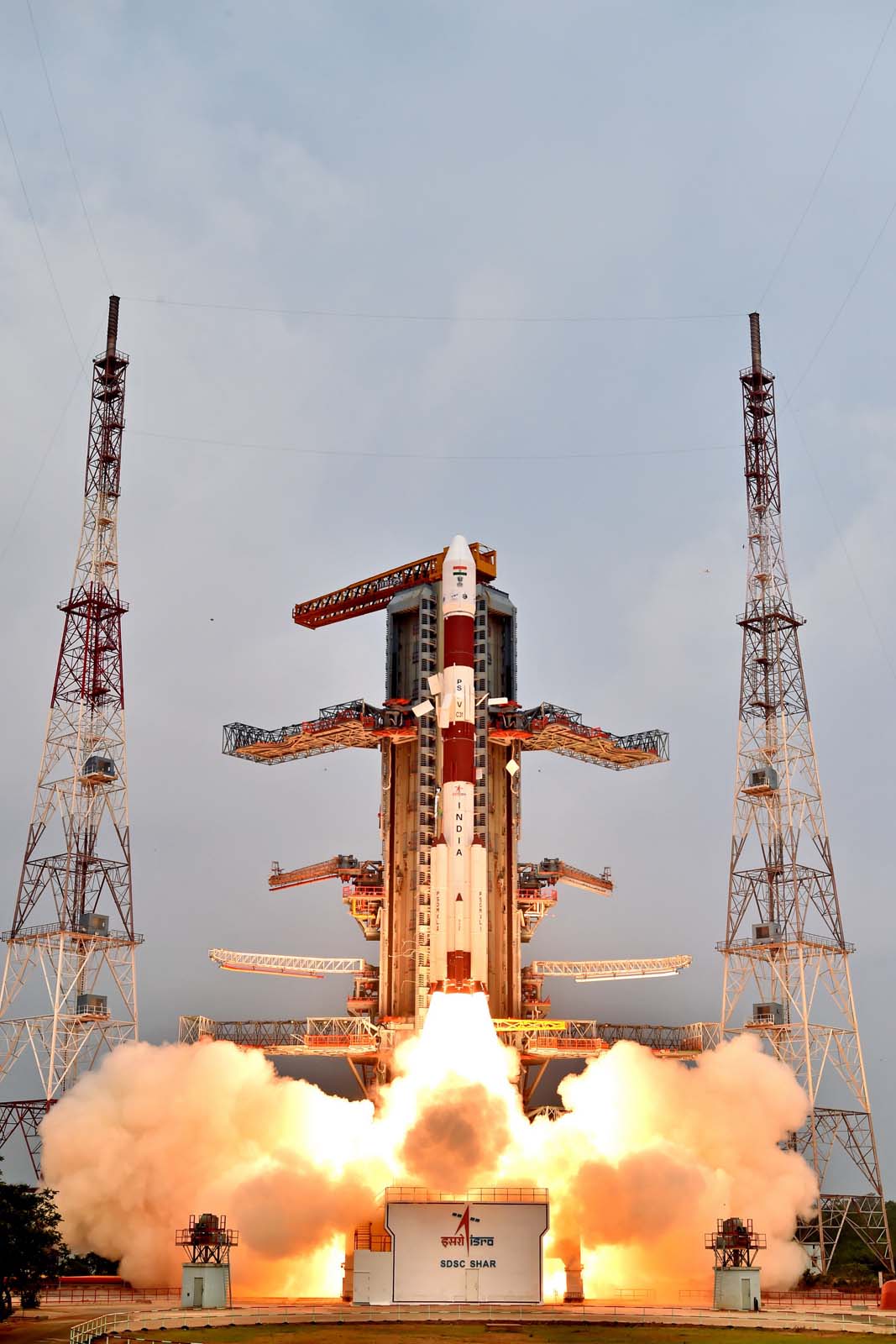
The 36 hur count down began on monday and the ground crew filled the PSLV's second and fourth stages with liquid fuels.   The PSLV-C36 lifted off at 04:55 GMT and climbed through a heavy rain shower and low clouds from the First Launch Pad of Satish Dhawan Space Center with 1.7 million pounds of thrust. 

The first four of the 12 meter auxiliary motors ( strap-on motors ) burned out and jettisoned around 70 seconds after lift-off followed by release of the last pair of boosters at T+92 seconds.   The first stage of the rocket consumed the solid propellant by T+1 minute and 50 seconds giving way to the Rocket's hydrazine-burning second stage Vikas Engine around 74 kilometers above Earth for a firing which lasted about 2 and 1/2 minutes with 1,80,000 pounds of thrust.   The onboard computers began closed-loop guidance during the second stage burn and the rocket's 3.2 meter diameter payload fairing fell down from the rocket at T+150 seconds.  

The PSLV headed eastwards first and then turned south in a "dogleg" maneuver to avoid flying over Sri Lanka accelerating to orbital velocity over Indian Ocean.   Once the Vikas Engine ( second stage ) emptied its 42 metric tonne supply of hydrazine and nitrogen tetroxide propellants, the third stage ignited around T+4 minutes 23 seconds for nearly two minutes and then coasted off until separating from the Rocket's fourth stage at around T+ 8 minutes 41 seconds.  

The twin engine liquid fueled fourth stage took control  of the mission at T+ 8 minutes 51 seconds for an eight minute firing to obtain proper velocity to enter the targeted polar orbit.  Resourcesat-2A was separated at around 18 minutes after lift-off.  

The Resourcesat-2A will track agriculture, water resources, soil contamination and the growth of Indian cities.  This is a follow up for Resourcesat 1 and Resourcesat 2 launched earlier in 2003 and 2011.  The spacecraft was put into an orbit of 823 Kms high at an inclination of 98.7 degrees to equator.

The PSLV-C36 launched on wednesday demonstrated several upgrades to the PSLV's avionics systems including the improved navigation system, a fiber-optic gyroscope, indigenously-produced computer processors and an automated fueling system to the fourth stage.  The streamlined automatic fuelling system saved one day in the launch preparations and also for a safe work environment for ground engineers to prepare the rocket.

Here is a video of PSLV-C36 Launch  ....


India's PSLV-C35 successfully places eight satellites into two different orbit in a single flight

Again Indian Space Research Organization has made history by placing eight satellites into two different orbits in a single mission using PSLV-C35 Rocket.  In its 37th flight ( PSLV-C35) india's Polar Satellite Launch Vehicle has successfully launched the 371 Kg SCATSAT-1 along with seven co-passenger satllites on 26th September, 2016 from its space port Satish Dhawan Space Center, Sriharikota  

This is the 36th consecutive successful flight of PSLV.  The total weight of the satellites is 675 Kg.  This is the first mission of PSLV to launch satellites into two different orbits and also this is the longest mission of PSLV till date and completed in 2 hours 15 minutes and 33 seconds after lift off.  

The PSLV-C35 lifted off at 09:12 hrs IST from the First Launch Pad of Satish Dhawan Space Center located at Sriharikota, Andhra Pradesh.  All the events like strap-on ignitions and separations, first stage separation, second stage ignition and separation, third stage ignition and separation, payload fairing separation, fourth stage ignition and cut-off took place as planned.  After 16 minutes and 56 seconds, the vehicle achieved a polar sun synchronous orbit of 724 Km with an inclination at an angle of 98.1 degrees to the equator and 37 seconds later the primary satellite SCATSAT-1 got separated.  

The two solar panels were deployed after separation of SCATSAT-1 and ISTRAC at Bangalore took the control of the satellite.  The satellite would provide weather related information using scatterometer payload.  The data would be useful in weather forecasting services as well as cyclone detection and tracking.  The PSLV mission continued after separation of SCATSAT-1 carrying the other 7 satellites.  The 4th stage coasted over the south pole and started ascending towards northern hemisphere.  After 1 hour 22 minutes 38 seconds after lift-off as the fourth stage was in North Pole region, the two engines of fourth stage were reignited and fired for 20 seconds.  Due to this firing, the rocket entered into an elliptical orbit of 725 Km  x  670 Km.   

The PSLV once again was coasting near south pole after 50 minutes, the engines were fired once again for 20 seconds.  This second firing made the fourth stage to enter into a circular orbit of 669 Km height inclined at 98.2 degrees to the equator.  After 37 seconds, the dual launch adopter was successfully separated from PSLV-C35 fourth stage.  30 seconds later, ALSat1N satellite got separated.  Following this, the NLS-19, PRATHAM, PISAT, ALSAT-1B, and Path finder-1 were separated in a pre determined sequence.

PRATHAm weighing 10 Kg and PISAT weighing 5.25 Kg  were made by Indian universities and academic institutions with the involvement of students of IIT Mumbai and PES University, Bangalore.   

Here is a video of PSLV-C35 Launch.....

Sunday, September 11, 2016

GSLV-F05 places India's Advanced Weather Satellite INSAT-3DR into orbit on 8th September, 2016

The Indian Space Research Organisation ( ISRO ) on thursday, 8th September, 2016 successfully placed its advanced weather satellite INSAT-3DR using the GSLV-F05 Launch Vehicle.

This is the maiden operational flight of the heavy-duty Rocket GSLV-F05 of India fitted with indigenous cryogenic upper stage.  The advanced weather satellite INSAT-3DR was successfully placed into the intended orbit by GSLV-F05 on thursday, 8th September, 2016 at exactly 16:50 hrs IST from the space port of India, Sriharikota.

The 49 meter GSLV-F05 lifted off from the second launch pad at Satish Dhawan Space Center, Sriharikota at 4:50 PM and injected the 2,211 Kg INSAT-3DR satellite into a Geosynchronous Transfer Orbit about 17 minutes later.  It was origninally scheduled to lift off at 4:10 PM IST but due to a delay in Cryo stage filling operations, it was rescheduled to 4:50 PM.

The INSAT-3DR has a mission life of 10 years and will provide service continuity to earlier meterological satellites and further augment the capability to provide various meteorological, search and rescue services.    This is the 10th GSLV flight and assumes significance because this is the first operational flight of GSLV fitted with Indian Cryo stage.  Earlier GSLV launches were under developmental phase.  GSLV-F05 marked a hat-trick of success for the indigenously developed Cryo stage after GSLV-D5 ( January, 2014) and GSLV-D6 ( August, 2015 ) missions which launched GSAT-14 and GSAT-6 satellites into space.

The orbit raising operations from Master Control Facility at Hasan were also successful.  INSAT-3DR would supplement the services of INSAT-3D launched from French Guiana on 26th July, 2013.  The payloads of this satellite are Imager, Sounder, Data-Relay Transponder and Satellite aided search and rescue transponder.  The images would generate the images of Earth every 26 minutes and provide information about various parameters, sea surface temperature, snow cover, cloud motion winds.  The sounder would provide informatio about temperature and humidity.  The data relay transponder will be used for receiving meteorological, hydrological and coeanographic data.  The satellite aided search and rescue transponder would pick up and relay alert signals originating from distress beacon of maritime, aviation, among others.

Here is a video of the live launch.....

India successfully tests its ScramJet Engine technology - ATV D02

An ATV rocket, fitted with two scramjet engines, lifts off from the Satish Dhawan Space Centre (SDSC) in Sriharikota on Aug. 28, 2016.In an attempt to make the rockets lighter and carry heavier payloads, ISRO has planned to flight test the air-breathing rocket which will use atmospheric oxygen as fuel.  Air breathing engines use atmospheric oxygen and burn it with the stored on-board fuel to generate the upward thrust.  Conventional rockets carry both oxygen and fuel on board.

ISRO on 28th August, 2016 has successfully tested a pair of its scramjet engines - an air breathing ramjet in which combustion takes in a super sonic air flow.  The engines were tested during a sub-orbital flight of Advanced Technology Vehicle ( ATV D02).

The total weight of the ATV rocket was 3270 Kgs and is based on Rohini-560 lifted off from Satish Dhawan Space Center, Sriharikota at 06:00 AM IST on 28th August, 2016.  The total flight duration lasted about 5 minutes is the India's first experimental mission of the scramjet engine technology to develop indigenous air-breathing propulsion system..

During the flight, ISRO has tested the scramjet engines for five seconds.  Once the second stage reached the desired conditions for start-up of the engine, the scramjet engines ignited and worked for about 5 seconds.  The total mission of ATV-D02 ended with a planned touch down of the rocket in Bay of Bengal at about 320 Kilometers from Sriharikota.  All the tests were conducted successfully as per ISRO statement.

The scramjet engines which use atmospheric oxygen can cut the costs of rocket launches by reducing the amount of oxidizer needed to be carried along with the fuel.  With this flight,  India became the fourth country in the world to flight test a scramjet engine.  This launch marks an important mile stone in Indian space programme.

The mission which was earlier scheduled in July, 2016 was delayed due to the disappearance of Indian Air Force AN 32 plane on July 22, 2016 as many ships and aircrafts were patrolling the sea looking for the missing plane and people.

Here is a video about ATV-D02 Mission.


Saturday, July 23, 2016

What is the speed at which Earth is moving?

We all feel that we are standing still on Earth.  We do not feel any movement in our surrounding areas.  But if we see at the sky, we can find evidence that we are moving.  

Some of the earliest astronomers proposed that Earth is at the center of everything and Sun rotated around us which caused sun rise and sun set - the same for movement of moon as well as planets.  This theory is not correct because some times a planet would back up in the sky before resuming its forward direction.. We know that this motion called retrograde motion - happens when Earth is "catching up" with another planet in its orbit.  If we take example Mars orbits farther from sun than Earth.  At one point in respective orbits of Earth and Mars, we catch up to the Mars and pass it by.  As we pass it by, the planet moves backwards in the sky.  Then it moves forward again as we have passed.

We know that it takes 365 days for Earth to orbit around Sun.  If we look at a close-up star in summer and look at it again in winter,  its position in the sky changes because we are at a different point in the orbit.  We see the star from different vantage points.  With simple calculations, using parallax, we can figure out the distance to the star.  Now let us see how fast are we moving..


How fast is the Earth spinning?

The spin of Earth is constant  but the actual speed depends on what latitude you are located. The circumference of Earth is roughly 40,070 kilometers ( around the equator ).  if we estimate that a day is 24 hours long,  we get a speed of Earth at Equator as 1.670 Kms per hour.   This is the fastest speed because we will not be moving at this speed at other latitudes.

If we move half way up the globe to 45 degrees in latitude ( either north or south ), we can calculate the speed by using the cosine of the latitude.  The cosine of 45 degrees is 0.707, the spin speed at 45 degrees latitude is roughly 0.707 X 1.67 = 1.18 Kms per hour.  This speed decreases as we move either towards north or south poles.  When you reach north or south poles, the speed is very very slow.  -  It takes entire day to spin in place.

The space agencies try to take advantage of the Earth's spin.  If they want to send humans to International Space Station, the preferred location to do so is close to Equator.  This is the reason space shuttles are launched from Florida.  By doing so and launching in the same direction of Earth's spin, the rockets get a speed boost to help them fly into space.  Now let us see how fast are we orbiting the Sun?


How fast is the Earth spinning?

The spin of the Earth is not only the motion we have in space.  The Earth also rotates around sun at a speed of about 1,07,000 Kms per hour.  We can calculate this also with the help of mathematics.

The earth takes about 365 days to orbit the Sun and the orbit is an Ellipse. To make the maths simpler,  let us assume that it is a circle..So the orbit of Earth is the circumference of a circle.  The distance of Earth from sun is  14,95,97,870 Kilometers, this is called as Angstrom Unit.   The circumference of Earth is equal to  2 x Ï€ x r,  so in one year, Earth travels about 940 million kilometers.  We know that the speed is equal to distance travelled by the time taken,  Earth's speed in our orbit around Sun is calculated by dividing 940 million kilometers by 365.25 days and dividing that results by 24 gives us the speed in Kilometers per hour...  Earth travels about 2.6 million kilometers in a day or 1,07,226 Kms per hour ( 29.785 Kms per second)..

The Sun and Galaxies also move.....

Do you know that the Sun has an orbit of its own in the Milky Way Galaxy.  The Sun is about 25,000 light years from the center of Milky Way Galaxy.  and the Milky Way is thought to be about 1,00,000 light years across.  We are thought to be about half way out from the center according to Stanford University.  The sun and solar system appear to be moving at 200 Kms per second or an average speed of 8,28,000 Kms per hour.  Even at this rapid speed, the solar system takes about 230 million years to travel all the way around Milky Way Galaxy.

Our Galaxy also moves in space relative to other galaxies.  In 4 billion years, our galaxy would collide with its nearest neighbour, the Andromeda Galaxy.  The two are rushing towards each other at about 112 Kms per second.   So everything in the universe is in motion.

What happ ens if Earth stops rotating.....


what would happen if the process was more gradual?  This is a more likely scenario over billions of years because Sun and Moon are tugging on Earth's spin.  This would give plenty of time for the humans, animals and trees to get used to the change. By laws of physics, the slowest spinning speed of Earth would be one revolution every 365 days..This situation is called as "Sun Synchronous" and would force one side of our planet to always face the Sun and other side to permanently face away.  Our moon is already in Earth-synchronous rotation where one side of moon is always facing us.

There would be other effects if the Earth completely stopped spinning.  As per NASA, the magnetic field would disappear because it is thought to be generated due to spin. We would lose out colourful auroras, and the Van Allen radiation belts surrounding our planet would probably disappear too.  Then Earth would be naked against the fury of the Sun.  Every time the Sun sends a coronal mass ejection towards Earth, it would hit the surface and bathe everything in the radiation.

Another effect : most spots on Earth would have day light for half a year and nights for other half.  The surface temperature during the day would change depending on the latitude you are in.  The Equator would be hotter than it is now because the Sun rays directly fall on it.  There will not be sun rise and sun set at poles.  The sun simply would just move up and down in the sky during the year according to the orbit and tilt.  .This long term temperature gradient would change the atmosphere wind circulation pattern.  The air would move from equator to the poles rather than in wind systems parallel to equator like they are now.

Secret NRO satellite mounted on top of Atlas 5 rocket for the launch on 28th July, 2016

File photo of Atlas 5 payload installation. Credit: ULAA spy satellite NROL-61 of US National Reconnaissance Office, the Government Agency which oversees the country's spy satellite fleet which is to be launched on 28th July, 2016 has been mounted atop an Atlas 5 rocket on 20th July, 2016 morning.

United Launch Alliance will perform the deployment mission on 28th July, 2016.   The rocket will head in easterly direction away from Cape Canaveral along an initial flight azimuth of 99 degrees.   The lift off of the Atlas 5 is planned at 08:37 AM EDT ( 12:37 GMT ) on 28th July, 2016.  The duration of the visible launch window is a secret.  but some source of information says that lift off may be at 1200 noon EDT ( 1600 GMT).  The rocket will be operating in its 421 configuration with a 14 foot wide nose cone, two side-mounted solid boosters and a single engine Centaur upper stage.

This is the first time NRO has has used the Atlas 5-421 rocket to launch one of its satellites. The payload was delivered to the vertical integration facility which is adjacent to the Complex 41 on 20th July, 2016 morning.  The spy satellite was lifted off from its transporter by overhead crane and maneuvered atop the Centaur upper stage for mating.   Some of the statistics of NROL-61 are listed below.

  • This is the 646th launch for Atlas program since 1957
  • This is 351st Atlas launch from Cape Canaveral
  • 235th mission of a Centaur upper stage
  • 212th use of Centaur by an Atlas rocket
  • The 470th production RL10 engine to be launched
  • The 13th RL10C-1 engine launched
  • The 70th flight of the RD-180 main engine
  • The 64th launch of an Atlas 5 since 2002
  • The 53rd launch of an Atlas 5 from Cape Canaveral
  • The 4th Atlas 5 launch of 2016
  • The 96th Evolved Expendable Launch Vehicle flight
  • The 13th National Reconnaissance Office use of Atlas 5
  • The 109th United Launch Alliance flight overall
  • The 56th Atlas 5 under United Launch Alliance
  • The 23rd NRO launch by United Launch Alliance
  • The 78th United Launch Alliance flight from Cape Canaveral
  • The 43rd 400-series flight of the Atlas 5
  • The 6th Atlas 5 to fly in the 421 configuration
  • The 45th NRO launch since acknowledging flights in 1996
  • The 22nd NRO launch from the Cape Caneraval
  • The 3rd NRO launch this year

European Space Agency plans to clean the Space Debris

The European Space Agency ESA is planning a specialized capture mechanism to remove the space junk and pull down the abandoned satellites to burn up in atmosphere.

The e DeOrbit Mission, which is the ESA's Clean Space initiative, is designed to capture an ESA owned satellite which is now in low earth orbit around the Earth but not working at present.  If every thing goes well, the capture mechanism - like a robotic arm, net or a harpoon -  will latch on to the target in the year 2023 and bring it back to a place where it can safely burn up in Earth's atmosphere.  


But we do not know whether this kind of plan works or not  and it is not an easy task.  There are several challenges that ESA scientists have to face.   They have to identify the fast moving target, find a safe and secure way to chase it down and capture it and synchronize the orbital paths with the satellite to bring it down into our Atmosphere in a controlled manner. . 
Even though the concept is straight forward, the implementation may be difflcult  -  a De Orbit will be like nothing ESA has ever attempted before.  The chaser satellite needs extremely sophisticated guidance, navigation and control to synchronize the motion of the target and then capture it.  

For more details please visit :  http://www.space.com/33414-space-junk-cleaning-satellite-mission-2023.html


Sunday, July 10, 2016

India's PSLV-C34 blasts off with 20 satellites

In its 36th flight (PSLV-C34), the ISRO's Polar Satellite Launch Vehicle lifted off early Wednesday ( 22nd June, 2016 ) with an assortment of payloads for Indian Government, domestic universities, and institutions and companies from Indonesia, Canada, Germany and United States including a pathfinder satellite for Google's Terra Bella Earth observation mission.


The PSLV-C34 successfully launched the 727.5 Kg Cartosat-2 series satellites along with 19 other co-passengers on 22nd June, 2016 at 09:26 hrs IST. This is the 35th consecutive successful flight of PSLV and 14th in its 'XL' configuration.  The total weight of all the satellites was 1288 Kgs. The launch occured at 03:56 GMT on Wednesday.. 

The 44 meter tall rocket, boosted by its six strap-on motors climbed into a clear sky, initially veering south east from the launch base, then turning south once over the bay of Bengal.  The unusual trajectory, called a 'dogleg' maneuver, was required to avoid flying over Sri Lanka. 

Four of the strap-on motors were ignited at lift off, then the last pair fired at T+25 seconds moments later the PSLV accelerated faster than speed of sound. 

The first four strap-on motors were separated at T+70 seconds, followed by separation of other pair at T+92 seconds as the PSLV soars at an altitude of 47 Kilometers.  

The first stage motor burned out and separated at T+109 seconds and a fraction of a second later, the second stage's liquid fueled Vikas Engine turned on with a puff of exhaust visible to ground based cameras.  

The Vikas engine produced 180,000 pounds of thrust and burned 42 tons of Hydrazine and nitrogen tetroxide propellants during two-and-half minutes of operation.  The heat shield or the payload fairing, fell down into two halves at T+155 seconds to reveal the 20 satellites packaged on top of the rocket..

The third stage solid motor ignited at T+4 minutes 22 seconds, at an altitude of 217 Kms.  Finally a twin-engine liquid-fueled fourth stage assumed control of the mission at T+8 minutes 17 seconds for an eight minutes firing to reach the proper speed to enter the targeted polar orbit.

Here is a video of the PSLV-C34 Launch...


India’s Reusable Launch Vehicle-Technology Demonstrator (RLV-TD), Successfully Flight Tested

On 23rd May, 2016,  ISRO successfully flight tested the India's first winged body aerospace vehicle operating in hyperosonic flight regime.

In this experimental mission,  the HS9 solid rocket booster carrying the RLV-TD lifted off from the First Launch Pad at Satish Dhawan Space Center, Sriharikota at 07:00 hrs IST on 23rd May, 2016.  After successful flight of 91.1 seconds, the HS9 was burnt out following which both HS9 and RLV-TD mounted on its top coasted to a height of about 56 Kms.  At this height, the RLV-TD separated from HS9 booster and further ascended to a height of about 65 Km.


From the height of 65 Kms, the RLV-TD started its descent followed by atmospheric re-entry at around Mach 5 ( five times speed of sound ).  The navigation, guidance and control system of the vehicle steered it during this phase for safe descent.  After successfully surviving the high temperatures of re-entry with help of thermal protection system, the RLV-TD successfully landed at the defined landing spot over Bay of Bengal which is at a distance of 450 Km from Sriharikota.  The total flight duration from launch to landing lasted for about 770 seconds.

Some of the critical technologies like autonomous navigation, guidance and control, reusable thermal protection system and re-entry mission management were successfully validated.  

The final version of RLV would take about 10 to 15 years to get ready.

Here is a video of the RLV TD launch...


India launches 7th navigation satellite onboard PSLV-C33

In the 35th flight of PSLV ( PSLV-C33) of ISRO has launched the 1425 Kg IRNSS-1G, the 7th satellite in the Indian Regional Navigation Satellite System (IRNSS) on 28th April, 2016 from Satish Dhawan Space Center, Sriharikota.  This is the 34th consecutive successful mission of PSLV and the 13th in its 'XL' configuration. 

Honourable Prime Minister of India, Sri Narendra Modi congratulated all the ISRO scientists and the team ISRO for completing the IRNSS constellation and dedicated the IRNSS system to the nation and named it as "NavIC" ( Navigation Indian constellation ).

The PSLV-C33 lifted off at 12:50 Pm IST from the first launch pad with the ignition of first stage, the subsequent flight events took place as planned.  After 19 minutes and 42 seconds, the IRNSS-1G spacecraft was injected into the elliptical orbit of 283 Km x 20718 Km inclined at an angle of 17.867 degrees to the equator.

After separation, the solar panels of the IRNSS-1G were deployed automatically and ISRO's Master Control Facility at Hasan took over the control of the spacecraft.  The orbital manoeuvres were conducted by MCF and the satellite was finally placed into Geo stationary orbit at 129.5 degrees East longitude.

IRNSS-1G is the seventh and the last satellite in the IRNSS constellation.  Here is a video of the PLSV-C33 Launch..


India launches 6th Navigation satellite onboard PSLV-C32

India has launched the 1425 Kg IRNSS-1F, the sixth satellite in the Indian Regional Navigation Satellite System ( IRNSS) on 10th March, 2016 afternoon.  This is the 34th flight of PSLV launch vehicle. The launch took place from India's space port, Sriharikota.   This is the 12th PSLV flight in its 'XL' configuration. 


After the lift off at 16:01 IST from Second launch pad with the ignition of first stage, the subsequent important flight events took place as planned.   The IRNSS-1F satellite was injected to an elliptical orbit of 284 Km x 20719 Km inclined at an angle of 17.866 degrees to the equator after 19 minutes 14 seconds.  The solar panels of the spacecraft were deployed automatically after separation.  ISRO's Master Control Facility at Hasan took over the control of the satellite and placed the satellite into a Geostationary orbit at 32.5 degree East longitude.  This is the 6th of the seven satellites constituting the space segment of Indian Regional Navigation Satellite system.  IRNSS-1A, 1B, 1C, 1D and 1E were the first five satellites of the constellation were successfully launched by PSLV on July 02, 2013,  April 04, 2014, October 16, 2014, March 28, 2015 and January 20, 2016 respectively. 

The IRNSS is an independent regional navigation system designed to provide position information in the Indian region and 1500 Km around the Indian main land.  The IRNSS would provide two types of services namely, Standard positioning services (SPS)- provided to all users and Restricted Services ( RS )  provided to authorized users.  

There are a number of ground stations responsible for the generation and transmission of navigation parameters, satellite ranging and monitoring etc.  18 stations have been established across the country.  

Here is a video of the PSLV-C32 LAUNCH...


Sunday, January 24, 2016

India launches 5th Navigation Satellite onboard PSLV-C31

ISRO has launched PSLV-C31 rocket on Wednesday, 20th January, 2016.  The Rocket carried the fifth navigtion satellite of India - IRNSS-1E and launched it into its orbit.  With this launch, India is closer to having its own global positioning system (GPS).  Two more satellites are to be launched in this constellation.

The PSLV-C31 blasted off from the Second Launch Pad of the Space port of India - Sriharikota as per schedule.   The rocket took off at 9:31 AM  IST. The life span of the satellite is 12 years.

The constellation of 7 satellites is planned to be completed this year itself.  The full system comprises of 9 satellites - seven in the orbit and two on the ground as stand-by.   The first satellite in the constellation - IRNSS-1A was launched in July, 2013,  the second in April, 2014, the third in October, 2014 and the fourth one was launched in March, 2015.  

Once the Regional Navigation System, India need not depend on other platforms for GPS services.  The IRNSS satellites two types of payloads - One is Navigation payload and the other is Ranging payload.  The navigation payload of IRNSS-1E will transmit navigation signals to the users.  This payload will operate in L5 band and S-Band.

A highly accurate rubidium atomic clock is a part of the navigation payload.  The ranging payload of this satellite consists of C-band transponder which facilitate accurate range of the satellite.  The IRNSS-1E also carries corner cube retro reflectors for laser ranging.

As PSLV-C31 soared into the blue sky at the end of 48 hours count down, all the four stages of the launch vehicle executed their functions as expected.  The two solar panels of IRNSS-1E were deployed automatically after injection of the satellite into the geo transfer orbit.  The orbit raising operations would be done from the Master Control Facility in Karnataka.  The weight of IRNSS-1E is 1,425 Kg.

Here is a live video showing the launch of PSLV-C31.